Battle for Fort Clinton
|
|
This Site:
|
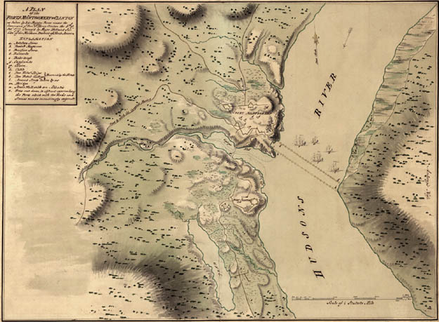
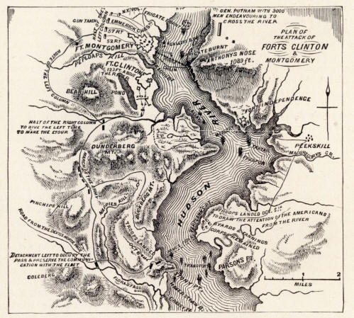
Original Map of Fort ClintonClinton, FORT, CAPTURE OF. While Burgoyne was contending with Gates on the upper Hudson, in 1777, Sir Henry Clinton was attempting to make his way up the river, to join him or to make a diversion in his favor. Among the Hudson Highlands were three forts of considerable strength, but with feeble garrisons—Fort Constitution, opposite West Point, and Forts Clinton and Montgomery, on the west side of the river at the lower entrance to the Highlands, standing on opposite sides of a creek, with high, rocky shores. From Fort Montgomery, on the northern side of the stream, to Anthony's Nose, opposite, the Americans had stretched a boom and chain across the river to prevent the passage of hostile vessels up that stream. Forts Clinton and Montgomery were under the immediate command of Governor George Clinton, and his brother General James Clinton. Tories had informed Sir Henry Clinton of the weakness of the garrisons, and as soon as expected reinforcements from Europe had arrived, he prepared trans-ports to ascend the river. He sailed (October 4, 1777) with more than 3,000 troops, in many armed and unarmed vessels, commanded by Commodore Hotham, and landed them at Verplanck's Point, a few miles below Peekskill, then the headquarters of General Putnam, commander of the High-land posts. He deceived Putnam by a feigned attack on Peekskill, but the more sagacious Governor Clinton believed he designed to attack the Highland forts. Under cover of a dense fog, on the morning of the 6th, Sir Henry re-embarked 2,000 troops, crossed the river, and landed them on Stony Point, making a circuitous march around the Dunderberg to fall upon the Highland forts. At the same time, his armed vessels were ordered to anchor within point-blank-shot distance of these forts, to beat off any American vessels that might appear above the boom and chain. Sir Henry divided his forces. One party, led by General Vaughan, and accompanied by the baronet (about 200 strong) , went through a defile west of the Dunderberg, to strike Fort Clinton, while another party (900 strong), led by Colonel Campbell, made a longer march, back of Bear Mountain, to fall on Fort Montgomery at the same time. Vaughan had a severe skirmish with troops sent out from Fort Clinton, on the borders of Lake Sinnipink, near it; at the same time the governor sent a messenger to Putnam for aid. The messenger, instead, deserted to the British. Campbell and his men appeared before Fort Montgomery at 5 P.m. and demanded the surrender of both forts. It was refused, when a simultaneous attack by both divisions and by the vessels in the river was made. The garrison (chiefly militia) made a gallant defense until dark, when they were overpowered and sought safety in a scattered retreat to the adjacent mountains. The governor fled across the river, and at midnight was in the camp of Putnam, planning future operations. His brother, badly wounded, made his way over the mountains to his home at New Windsor. Some American vessels lying above the boom, unable to escape, were burned by their crews. By the light of this conflagration the fugitive garrisons found their way through the mountains to settlements beyond.
Fort Clinton Battle Map |
|
|
||
|
|
Site Copyright 2003-2018 Son of the South. For Questions or comments about this collection, contact: paul@sonofthesouth.net |
|
|
Are you Scared and Confused? Read My Snake Story, a story of hope and encouragement, to help you face your fears. |
||