Westward Expansion
![]()
This Site:
|
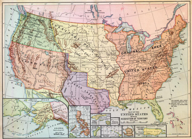
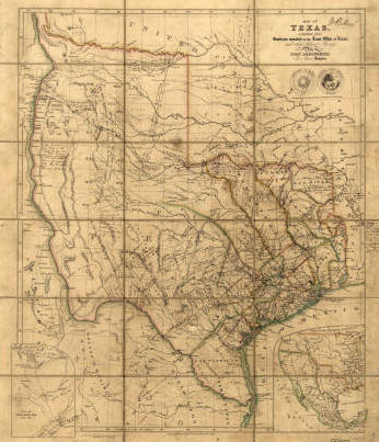
WESTWARD EXPANSION. The original territory of the United States as acknowledged by the treaty with Great Britain, in 1783, consisted of the following thirteen States: New Hampshire, Massachusetts Bay, Rhode Island and Providence Plantations, Connecticut, New York, New Jersey, Pennsylvania, Delaware, Maryland, Virginia, North Carolina, South Carolina, and Georgia. The boundaries of many of these States, as constituted by their charters, extended to the Pacific Ocean; but in practice they ceased at the Mississippi. Beyond that river the territory belonged, by discovery and settlement, to the King of Spain. All the territory west of the present boundaries of the States was ceded by them to the United States in the order named: Virginia, 1784; Massachusetts, 1785; Connecticut, 1786 and 1800; South Carolina, 1787; North Carolina, 1790; Georgia, 1802. This ceded territory comprised part of Minnesota, all of Wisconsin, Michigan, Illinois, Indiana, Ohio (see NORTHWEST TERRITORY), Tennessee, and a great part of Alabama and Mississippi. Vermont was admitted as a separate State in 1791; Kentucky, then a part of Virginia, in 1792; and Maine, till that time claimed by Massachusetts, in 1820. Louisiana PurchaseSpain's restriction of the navigation of the Mississippi, the great natural commercial artery of the American continent, was a great annoyance to the settlers on the western slopes of the Alleghanies. It was not until Oct. 17, 1795, and after many attempts, that Thomas Pinckney succeeded in negotiating a treaty of friendship, boundaries, and navigation. On Oct. 1, 1800, by the treaty of St. Ildefonso, Spain retroceded to France the vast province of Louisiana. Bonaparte's design to revive, in New Orleans, the former colonial glories of the French monarchy more and more menaced the United States; navigation was again closed; and in Congress, James Ross, Senator from Pennsylvania, introduced resolutions authorizing the President to call out 50,000 militia and to take possession of New Orleans. Instead of this, Congress appropriated $2,000,000 for the purchase of the city, and sent James Monroe, as minister extraordinary, to cooperate with Livingston, minister to France, in the proposed purchase. April 11, 1803, Livingston, who had already begun negotiations for the purchase of New Orleans, was suddenly invited by Napoleon to make an offer for the whole of Louisiana. On the following day Monroe arrived in Paris, and the two ministers decided to offer $10,000,000. The price was finally fixed at $15,000,000, one-fourth of it to consist in the assumption by the United States of $3,750,000 worth of claims of American citizens against France. The treaty was in three conventions -to secure the cession, to ascertain the price, to stipulate for the assumption of the claims —all signed the same day, April 30, 1803, by Livingston and Monroe on one part, and Barbe-Marbois on the other. This vast purchase added 1,171,931 square miles to the territory of the United States, including Alabama and Mississippi south of the parallel of 31°; all of Louisiana, Arkansas, Oklahoma, Indian Territory, Missouri, Nebraska, Iowa, North Dakota, South Dakota, and Montana; Minnesota, west of the Mississippi; Colorado and Wyoming, east of the Rocky Mountains; and Kansas, with the exception of the southwestern corner. The western boundary was not finally settled until after the purchase of Florida, in 1819. Florida PurchaseThe boundary between Louisiana and Florida had been long in dispute, Spain claiming all that territory south of the parallel of 31° and east of the Mississippi River, and the United States fixing it at the Perdido River, the present boundary between Florida and Alabama. In 1810, the people of west Florida met at Baton Rouge and declared themselves independent, and Governor Claiborne, of the Territory of Orleans, was sent by the President to take possession; in 1812 the Pearl River was made the eastern boundary of Louisiana, and the remainder of west Florida was annexed to Mississippi Territory ; in 1813 the fort and city of Mobile were taken by General Wilkinson. During this period a determination of gaining east Florida had been growing rapidly, and Congress, by acts passed in secret, in January and March, 1811, had authorized the President to take temporary possession. In 1818, during the Seminole War, being annoyed by Spanish assistance given to the Indians, Jackson raided east Florida, captured St. Marks and Pensacola, and hanged Arbuthnot and Ambrister, two British subjects who had given aid and comfort to the Indians. This demonstrated so completely that Florida was at the mercy of the United States that the Spanish minister at Washington signed a treaty, on Feb. 22, 1819, by which Spain ceded Florida, in return for the payment of claims of American citizens against Spain, amounting to $5,000,000. The ratification by Spain was not secured till 1821, Spain attempting to obtain the refusal of the United States to recognize the independence of the revolted Spanish-American colonies. The territory purchased comprised 59,268 square miles. OregonThe treaty with Spain in 1821 settled the western boundary of the Louisiana purchase as follows : " Beginning at the mouth of the Sabine, in the Gulf of Mexico; up the west bank of the Sabine to the thirty-second degree of north latitude; thence north to the Red River; along the south bank of the Red River to the one-hundredth degree of longitude east from Greenwich; thence north to the Arkansas; thence along the south bank of the Arkansas to its source ; thence south or north, as the case may be, to the forty-second degree north latitude, and along that parallel to the Pacific Ocean." This put out of dispute the territory comprising the present States of Washington, Oregon, Idaho, and the western part of Wyoming, claimed by the United States on the grounds of discovery (1792), exploration (1805), and settlement (1811). The boundary between the States of Washington and Idaho, on one side, and Canada, on the other, was finally determined in 1848. Republic of Texas
Mexico and CaliforniaThis territory, comprising 545,783 square miles, and including the present States of California, Nevada, and Utah, and a large part of Arizona and New Mexico, and part of Colorado, came to the United States as a result of the MEXICAN WAR, through conquest and purchase. The treaty, known as the treaty of Guadeloupe Hidalgo, was signed Feb. 2, 1848, and was ratified by the Senate March 10, the United States paying $15,000,000 in addition to assuming the payment of claims of American citizens against Mexico amounting to $3,250,000. Gadsden PurchaseIn 1853 the United States bought from Mexico a strip of land, now forming that part of Arizona and New Mexico lying south of the Gila River and extending from the Rio Grande, near El Paso, on the east, to the Colorado River on the west. GEN. JAMES GADSDEN was at that time minister to Mexico and negotiated the transfer, and this territory, 45,535 square miles in ex-tent, has always borne his name. AlaskaThis valuable fur and mineral producing country was first claimed by Russia by right of discovery. By treaty of March 30, 1867, ratified by the Senate in special session, June 20, 1867, Russia ceded the whole of the territory, 557,390 square miles in extent, to the United States for $7,200,000. See ALASKA. HawaiiIn January, 1896, a joint resolution was introduced into the Lower House of the United States Congress providing for the annexation of the Hawaiian Islands, and was referred to the committee on foreign affairs. On June 16, 1897, a treaty was signed in Washington by representatives of both governments and transmitted to the Senate. The committee on foreign relations reported favorably upon it, but the Senate adjourned without action. In Hawaii, the treaty was ratified by both Houses of the Congress by unanimous vote, Sept. 10. Many attempts were made in later sessions of Congress, but it was not till June 6, 1898, when the United States Senate adopted a direct annexation resolution, that anything was accomplished towards the acquisition of the islands. The President signed the resolution on the following day, and ordered the cruiser Philadelphia to proceed to Honolulu , and raise the American flag. Commissioners were appointed to prepare a plan for the future government of the islands, and formal possession was taken on Aug. 12, 1898. See BLOUNT, JAMES H.; HAWAII. Wake IslandThis low-lying atoll in the midst of the Pacific Ocean, half-way between the Hawaiian Islands and the Philippines, was taken possession of, in the name of the United States, by a landing-party under the command of Commander Edward D. Taussig, of the U. S. S. Bennington, Jan. 17, 1899. Wake Island is said to have been by rights already American territory, since, in 1851, Admiral Wilkes surveyed the place and asserted title. As a cable station, in view of the laying of a Pacific cable, it will be invaluable. See WAKE ISLAND. Porto RicoThis large and fertile island, together with its outlying smaller islands, came into the possession of the United States at the close of the Spanish-American War, by the ratification of the treaty of peace (1899). At the time of the suspension of hostilities General Miles was conducting a campaign in the island. He had met with very little resistance, and had been treated by the natives on every hand more as a liberator than a conqueror. The island has valuable natural resources and possesses a delightful climate. See PORTO RICO Philippine Islands.After his great victory in Manila Bay, May 1, 1898, Dewey refrained from attacking the city until he could receive co-operation from the land forces. General Merritt, as first military governor of the Philippines, was dispatched immediately with a large military force, which was landed during the months of June and July. The first land engagement took place on Aug. 9, near Malate, and the city was stormed and captured on Aug. 13, one day after the signing of the protocol, a fact of which the American generals were in ignorance. The final treaty of peace (1899) ceded the en-tire group of islands to the United States upon the consideration of a payment of $20,000,000. See PHILIPPINE ISLANDS. GuamThe principal island of the Ladrone group, in the Pacific Ocean, was seized by the United States naval authorities on June 21, 1898, and was ceded by Spain to the United States by the treaty of peace following the Spanish-American War. Formal American possession was taken Feb. 1, 1899. On Oct. 4, 1900, by order of the Navy Department, Guam was made a separate naval and government station. The harbor of San Luis d'Apra is said to be one of the finest in the world. See AGANA; GUAM. SamoaThe independence and neutrality of the Samoan Islands were guaranteed in 1890 by tripartite agreement between Great Britain, Germany, and the United States. The political situation remained very peaceable until 1899, when some of the followers of Mataafa, the former king, then in exile, instigated a revolution. This was quickly suppressed by the interference of the above powers, who landed marines and put the insurgents to flight. Soon after quiet had been restored negotiations were entered into which resulted in the partitioning of the islands and the surrendering by Germany and Great Britain of all rights to the island of Tutuila, containing the magnificent harbor of Pago Pago, and all other islands of the Samoan group east of long. 171° W. of Greenwich. The treaty was ratified in the Senate, Jan. 16, 1900, and formal possession of the islands was taken by the President on March 16. SeeSAMOA ; TUTUILA. Cibitu and CagayanThe Peace Commissioners in Paris (1899) who negotiated the transfer of the Philippine Islands from Spain to the United States drew a geographical boundary-line fixed by meridians of longitude and parallels of latitude. The lines described a parallelogram with the exception that there was an inset in the southwestern corner to exclude some islands off the coast of Borneo. A year after the signing of the treaty of Paris (1899), the fact was discovered that in laying down these boundaries the commissioners had excluded the islands of Cibitu and Cagayan of the Philippine group. After negotiations lasting for several months, in which Spain refused to recede from her position of ownership, the United States, in July. 1900, in order to remove cause of possible irritation as well as to protect herself from their future purchase by other European powers, bought the islands from Spain for $100,000. The islands are small and thinly populated, but are valuable for their pearl and shell fisheries. Ratifications of the treaty of cession were exchanged in Washington on March 23, 1901. |
![]()
|
Site Copyright © 2003-2018 Son of the South. For questions or comments, contact paul@sonofthesouth.net. |
|
|
|
Are you Scared and Confused? Click Here to read My Snake Story, a story of hope and encouragement, to help you face your fears. |
||