|
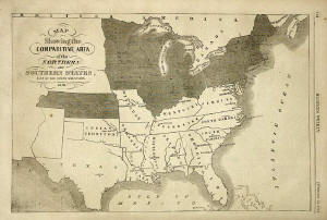
The image
above is one of the earliest known maps of the confederacy. It was printed in February 23,
1861, shortly after the secession of the southern states to form the Confederate States of America. The map appeared in the February 23, 1861 edition of Harper's Weekly. The map, for the first time, shows a nation divided; Divided, North and South, with the fate of Nations hanging in the balance.
The map contains the following title:
MAP
SHOWING THE
COMPARATIVE AREA
OF THE
NORTHERN
AND
SOUTHERN STATES,
EAST OF THE ROCKY MOUNTAINS
1861
The Union States are shown in Gray, and the
Confederate States are shown in White. This is one of the earliest maps of the Confederacy ever created. The
Southern States are shown to be: Texas, the Indian Territory (Oklahoma), Missouri, Arkansas, Louisiana, Mississippi, Tennessee, Kentucky, Virginia, Maryland, Delaware, North Carolina, South Carolina, Georgia and
Florida. This is a striking map, and was created before the start of the Civil War. This image of the Nation Divided must have created a sense of foreboding amongst the people of the day who saw it.
|